
A Deep Look at Nashville’s Flood Legacy — and Why the Music City Loop Tunnels Are Not the Threat Critics Fear
The 2010 flood reshaped Nashville’s understanding of disaster resilience and transformed how the city prepares for extreme weather. Critics of the Music City Loop argue tunnels could worsen flood risks, but the project’s design and global experience suggest otherwise. [Read more ➝]
By the LOOP Nashville Editorial Staff
10/3/20254 min read
Sources:
NOAA — Cumberland River Historic Crests
Reddit Boring Company Community — Vegas Loop Flash Flooding Discussion
Nashville’s Long Relationship with Floods
Nashville has always been shaped by water. The Cumberland River and its many tributaries have supported the city’s growth but have also unleashed destruction when storms proved too strong for existing defenses. The city’s history is punctuated with floods that reveal just how central resilience must be to its planning.
In 1912, the collapse of the Eighth Avenue Reservoir wall unleashed 25 million gallons into surrounding neighborhoods, damaging homes and lives in a sudden catastrophe. By 1914, engineers rebuilt the structure with stronger walls and waterproofing, marking one of the city’s earliest infrastructure lessons in water resilience.
The great flood of 1918 pushed the Cumberland to 49.9 feet, overwhelming levees. In 1927, the river reached its highest crest on record at 56.2 feet, inundating neighborhoods and causing untold hardship. The 1937 flood followed at 53.9 feet, again bringing widespread devastation. Smaller but still costly floods struck in 1948 and 1951, reinforcing that the Cumberland and its tributaries demanded constant respect.
This history of floods set the stage for what would become the most devastating natural disaster in modern Nashville: the flood of 2010.
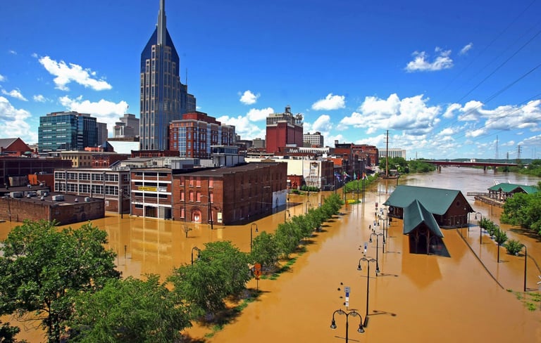
The 2010 Flood: When Records Fell
On May 1–2, 2010, the skies opened. Over the course of just two days, Nashville received more than 13.5 inches of rain, shattering all previous rainfall records. The Cumberland River crested at 51.86 feet downtown — more than 12 feet above flood stage — as creeks like Mill, Richland, and Whites surged over their banks.
The toll was staggering. More than $2 billion in damages were recorded in Greater Nashville, with downtown landmarks from the Grand Ole Opry House to the Bridgestone Arena flooded. Eleven residents in Nashville lost their lives, part of the 26 deaths across Tennessee and Kentucky. Interstate highways were closed by floodwaters, neighborhoods were submerged, and even critical facilities like the Omohundro Water Treatment Plant came within inches of failure.
For Nashville, 2010 was a turning point. The flood showed how quickly disaster could strike and how deeply vulnerable the city was to storms that may have once seemed improbable.
Building Resilience After 2010
The devastation of 2010 did not end with cleanup. Nashville invested heavily in resilience measures to prevent a repeat of that disaster. Riverfront Park, completed in 2015, became a showcase of green infrastructure, hiding serious flood protections behind its public amenities. It includes bioswales, permeable paving, a 375,000-gallon irrigation cistern, and a discreet flood wall built to withstand a crest two feet above the 2010 flood level.
Across Davidson County, Metro government worked with FEMA and TEMA to expand flood gauge networks, add floodplain mapping, and pursue buyouts for hundreds of flood-prone homes. Federal disaster relief funds were leveraged to rebuild smarter, not simply to restore the status quo. The city’s updated hazard mitigation plans prioritized strengthening stormwater systems and protecting critical infrastructure.
The result was not just recovery, but transformation — a city more prepared than ever to confront the extremes of water.
Tunnel Vision with Flood Resilience
Against this history, some opponents of the Music City Loop project warn that tunneling beneath Nashville risks compounding flood danger. Yet the design of the Loop demonstrates the opposite: that the project anticipates flood risk from the outset and builds in layers of protection.
According to The Boring Company, the tunnels are constructed using watertight segments sealed with gaskets, backed by a three-inch grout sealant on the outside. These measures render the tunnel lining effectively waterproof, even in saturated soils. The tunnels will lie well below the water table, a condition already proven safe by the Vegas Loop, which is almost entirely below the water table and has operated without issue.
Surface water entry points are limited to station portals. These entrances are elevated and outfitted with barriers and drains, ensuring water cannot freely flow into the system. Each station also includes high-power sump pumps designed to remove water quickly. The system is fully redundant, meaning that if one pump fails, others are in place to keep tunnels dry.
In the rare event of catastrophic flooding, safety remains paramount. The tunnels would be closed and evacuated immediately, protecting passengers from harm. Importantly, the responsibility for cleanup and repair would not fall on taxpayers. The Boring Company, as operator, would bear those costs directly.
The resilience of this approach was tested in Las Vegas in February 2025, when flash floods swept cars down the Strip and left parts of the city paralyzed. The Vegas Loop, despite being deep underground, remained open and unaffected, with no water infiltration reported. This real-world example underscores how tunnels designed to modern engineering standards can endure flood events that overwhelm surface infrastructure.
Far from introducing new flood risk, the Music City Loop has the potential to be among Nashville’s most resilient transit assets. Unlike roads and surface rail that can be submerged, an underground system designed with multiple layers of flood defense may prove to be one of the safest ways to move people when storms hit hardest.
Why It Matters
Floods will always be a part of Nashville’s story. The 2010 disaster reinforced that lesson in the most painful of ways. Yet the city’s response — from rebuilding Riverfront Park with a hidden flood wall to strengthening floodplain policy — shows that infrastructure can adapt and evolve.
The Music City Loop carries that same principle forward. By learning from history and by employing proven engineering, it seeks not to deny flood risk but to design for it. The fears voiced by critics are understandable, but the evidence suggests those fears should not prevent progress.


Disclaimer
LOOP Nashville aggregates publicly available news, commentary, and editorial content related to the Music City LOOP project. All source material is fully credited and attributed to its original publishers. All commentary and editorial opinions are solely those of the LOOP Nashville Editorial Staff. We are an independent site and are not affiliated with The Boring Company or the Music City LOOP project.
CONTACT
Follow
scoop@loopnashville.com
© 2025. All rights reserved.