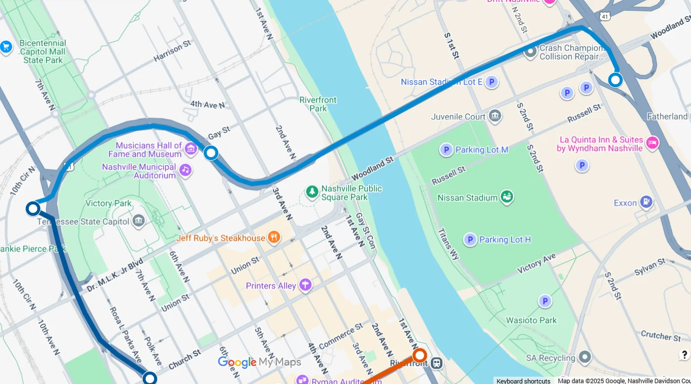
Interactive tunnel routes and station locations based on publicly available information.
READING THE MAPS
The announced network. And what could come next.
LOOP Nashville tracks the Music City Loop using public project announcements, station disclosures, corridor descriptions, easement records and other publicly available information.
The first map below reflects the project as it has been publicly announced. The second explores a potential expansion scenario if The Boring Company were to make greater use of additional state-controlled property and highway corridors. That second map is conceptual, not an announced plan.
01
CURRENT PLAN
Plan as announced
This map represents the Music City Loop network as it has been publicly announced to date, including publicly identified routes, corridors and station locations. It is our best snapshot of the plan currently on the table, while recognizing that engineering, permitting and station details may continue to evolve.
5publicly identified station projects
Loading the latest Plan as Announced map…
PUBLICLY ANNOUNCED ROUTES + STATIONS · UPDATED AS NEW INFORMATION BECOMES PUBLIC
02
CONCEPTUAL EXPANSION
What could come next
State-controlled property could create opportunities for a broader network than the one announced so far. This LOOP Nashville map illustrates one possible scenario if The Boring Company chooses to expand beneath additional state property and highway right-of-way to reach more major destinations.
IMPORTANT CONTEXT
This is a LOOP Nashville conceptual map. It is not an announced route plan and does not indicate that The Boring Company or the State of Tennessee has committed to these additional alignments or stations.
LOOP NASHVILLE CONCEPT
Announced network Conceptual expansion Potential destination
Loading the latest conceptual map…
LOOP NASHVILLE CONCEPT · YELLOW ROUTES SHOW HYPOTHETICAL EXPANSIONS · NOT AN ANNOUNCED BORING COMPANY OR STATE PLAN
WHAT THE YELLOW LINES COULD UNLOCK
Three extensions. Three major ridership plays.
The value of these hypothetical routes is not simply that they add mileage. Each one reaches a destination that can produce large surges of riders, while trying to keep the main tunnel alignment beneath property controlled by the State of Tennessee.
01
NORTH OF THE CAPITOL
First Horizon Park
A short extension north beneath the Bicentennial Capitol Mall area and adjoining state property could put a station directly across from First Horizon Park. The ballpark can hold roughly 10,000 people, making it the kind of destination where a nearby station could generate concentrated event-day ridership without sending thousands of additional cars into the urban core.
The strategic advantage is the right-of-way. As drawn, the route is intended to remain beneath state-controlled property, including the mall area and a state parking parcel. That could allow the main tunnel alignment to avoid Metro-owned streets and substantially reduce the number of local right-of-way approvals needed, although project-specific utility, construction and site approvals could still apply.
02
CUMBERLAND RIVER + EAST BANK
Ascend, the East Bank and Nissan Stadium
The yellow river crossing is deliberately not drawn as the shortest possible line between downtown and the East Bank. It is drawn around a different objective: finding a route that could remain, as much as possible, beneath state-controlled roads and transportation property.
From the downtown network, the concept follows U.S. 70 along 1st Avenue South toward the riverfront. That creates the opportunity for a station near Ascend Amphitheater before the alignment turns toward interstate right-of-way and crosses beneath the Cumberland. On the East Bank, it could then reach the new Nissan Stadium and connect back into state transportation property. The result is a longer and less direct crossing, but one designed to minimize reliance on Metro-owned streets for the main tunnel alignment.
That routing would connect two major event districts. Ascend Amphitheater holds about 6,800 people, while the new Nissan Stadium is being built for roughly 60,000 seats. A Loop branch serving both could move large surges of riders without requiring those trips to funnel across downtown bridges or onto already-congested surface streets.
WHY THIS LINE, AND WHAT ELSE COULD WORK?
There is more than one way across the Cumberland.
The yellow route is one state-right-of-way-first concept, not a claim that it is the best engineering alignment. A future river crossing could take several forms depending on which governments, property owners and transportation partners are willing to participate.
THE YELLOW ROUTE
U.S. 70 / 1st Avenue South + interstate property
This concept prioritizes jurisdictional simplicity over geometric simplicity. It uses U.S. 70 along 1st Avenue South to reach the riverfront, creates a logical Ascend Amphitheater station opportunity, then bends toward interstate property for the river crossing and East Bank approach. The advantage is a main tunnel corridor built around state-controlled transportation assets. The disadvantage is that it is not the most direct path from the existing downtown network to Nissan Stadium.
ALTERNATIVE 01
Broadway directly to the East Bank
The cleanest passenger route would simply continue the Broadway/West End tunnel east beneath the Cumberland toward the new TPAC campus and Nissan Stadium. It is the most direct connection between Nashville's major downtown activity centers and the East Bank and could place stations close to the stadium, riverfront parks and future civic development.
The tradeoff is jurisdiction. A direct Broadway crossing would require cooperation with the entities controlling East Bank property and station sites. From a transportation standpoint it may be the strongest alignment; from an approvals standpoint it could require the most partnership.
MOST DIRECT
ALTERNATIVE 02
James Robertson Parkway
Another state-oriented option could begin near the Rosa L. Parks Boulevard side of the network and follow James Robertson Parkway toward the river. That alignment could create a station opportunity near Nashville Municipal Auditorium before continuing toward the stadium district.
The attraction is that James Robertson Parkway is a state highway corridor with comparatively straight geometry. It would be less direct for riders coming from Lower Broadway, but could provide a cleaner governmental path and add another high-volume downtown venue to the network.
STATE-CONTROLLED CORRIDOR
ALTERNATIVE 03
CSX rail corridor + state property
A third concept would use portions of the existing CSX rail corridor and transition to state-controlled property where the rail right-of-way intersects interstate and other public parcels. That could produce a crossing farther north and create a route serving not only Nissan Stadium, but also the broader East Bank and future Oracle employment district.
This alternative could generate more all-day ridership than a stadium-focused route, but it would require a major private-sector agreement with CSX and careful coordination around an active freight corridor.
BROADEST EAST BANK REACH
ALTERNATIVE ALIGNMENT
James Robertson Parkway illustrates the basic idea.
This earlier LOOP Nashville concept shows how a crossing could be organized around a state highway corridor rather than the shortest possible path. The same principle drives the yellow line on the current map: use public transportation right-of-way to reduce the number of separate property interests the tunnel must cross.
THE BIGGER POSSIBILITY
A river crossing could be the beginning, not the endpoint.
Once the Loop reaches the East Bank, state-controlled corridors could provide paths farther into East Nashville. Ellington Parkway offers a potential northeast spine, and its connection with Briley Parkway could eventually create a route toward Opryland, hotel and convention properties, park-and-ride facilities and other regional destinations. A Cumberland crossing therefore matters not only because it reaches Nissan Stadium, but because it could establish the gateway for an entire east-side network.
03
SOUTH NASHVILLE
GEODIS Park
The southern extension would follow the U.S. 31A corridor along 4th Avenue South before turning toward GEODIS Park. The highway corridor provides a state-oriented path south from downtown, but a station serving the stadium would likely require a separate property agreement because the GEODIS Park site itself is controlled through Metro's Sports Authority rather than the State.
The transportation case is still compelling. GEODIS Park seats more than 30,000 people, and its own event guidance relies on a mix of on-campus parking, off-campus lots, rideshare, buses and other alternatives. A fast underground connection from downtown could give tens of thousands of fans another option while reducing event-day pressure on surrounding streets and parking lots.
Unlike the first two concepts, this extension would almost certainly require a willing local partner at the destination. But because the stadium's access and parking challenges are already a major part of the event-day experience, the case for a partnership with The Boring Company could be unusually strong.
WHY STATE RIGHT-OF-WAY MATTERS
The common thread is control of the tunnel corridor. Staying beneath state property or state highway right-of-way could simplify routing and reduce the number of local property and street approvals required. It would not eliminate every permit, utility coordination issue, station agreement or regulatory review, but it could give The Boring Company a cleaner path for extending the network between major destinations.